The Ink #12 - We thought we knew two. There were three all along.
A third manta ray species in the Atlantic, the first global seagrass map, and a deep-sea mining trial that cut abyssal fauna by 37%. The Ink #12, July 2026.
What is Mobula yarae and why is it a significant discovery?
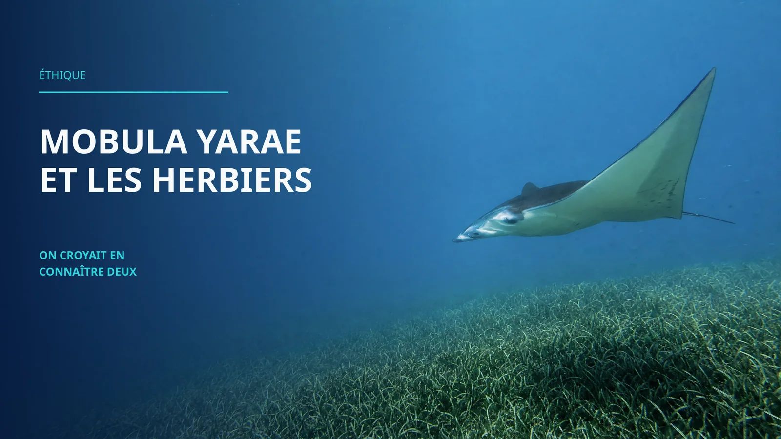
Mobula yarae is the third manta ray species formally described in the world. It inhabits tropical and subtropical Atlantic waters from the US east coast to Brazil, including the Gulf of Mexico and the Caribbean. For decades it was mistaken for the giant oceanic manta (Mobula birostris) due to near-identical morphology from above. Its formal description, published in Environmental Biology of Fishes, is the result of fifteen years of observations by the Marine Megafauna Foundation, combined with genetic analysis made possible by the natural stranding of an individual in Florida in 2017.
How much seagrass exists globally and where is it found?
The first high-resolution global seagrass map, published in Nature in 2026, identified 148,506 km² of seagrass meadows in waters down to 30 metres depth. Around 70% is concentrated off just five countries: the US, Bahamas, Cuba, Australia, and Indonesia. Only 21% falls within marine protected areas. Between 2019-2020 and 2023-2024, 4% of global seagrass area was lost.
What did the deep-sea mining trial in the Pacific reveal?
A study in Nature Ecology and Evolution documented an industrial nodule extraction trial at 4,280 metres depth in the eastern Pacific. Results: a 37% decrease in faunal density and 32% reduction in species richness within mining tracks. Areas affected only by sediment plumes showed unchanged abundance but altered community structure. The polymetallic nodules recovered are 1 to 10 million years old. The associated fauna does not recover on human timescales.
How is a cryptic species like Mobula yarae discovered?
A cryptic species is one that closely resembles a known species to the point of going undetected. Distinguishing Mobula yarae required genetic sampling, detailed morphological measurements, and analysis of specific belly markings (dark spots absent in its relatives). The natural stranding of an individual in Florida in 2017 provided the necessary material to complete the formal description. Field observations accumulated since 2009 by the MMF built the documentary case over fifteen years.
The Ink is a weekly series on recent marine discoveries. The ink of writing. The anchor of the deep. One issue, a handful of stories, and what they change when you dive with a camera.
"The sea does not reward those who are too anxious, too greedy, or too impatient. To dig for treasures shows not only impatience and greed, but lack of faith." Anne Morrow Lindbergh, Gift from the Sea, 1955
It is July 2026, and three pieces of news have arrived this week from places we thought we already knew.
The first comes from the tropical waters of the Atlantic, where a manta ray has been swimming since long before anyone thought to give it a distinct name.
The second comes from a study published in Nature, where researchers at Arizona State University have, for the first time, mapped all of the planet's seagrass meadows.
The third comes from 4,280 metres below the surface in the Pacific, where an industrial mining trial has produced data that can no longer be set aside.
These three stories have different origins. They point toward the same problem: we discover and damage the same places at the same moment, without the two operations seeming to be in conversation with each other.
The third manta ray in the Atlantic
For decades, marine biologists recognised two manta ray species in the world.
The reef manta ray (Mobula alfredi), smaller, associated with coastal zones. The giant oceanic manta (Mobula birostris), open-water, capable of diving below 1,000 metres.
And in the Atlantic, individuals that looked like the giant manta, but not quite.
The Marine Megafauna Foundation began documenting these individuals as early as 2009, in the waters off Florida, the Gulf of Mexico, and the Caribbean. MMF co-founder Dr. Andrea Marshall observed them with a persistent impression: something did not line up with the descriptions of Mobula birostris.
What allowed the question to be settled was a biological accident: in 2017, a naturally deceased individual washed up in Florida. Scientists were able to collect genetic samples, take precise morphological measurements, and analyse a distinctive marking that had not yet been formalised: dark spots on the belly, absent in both known species.
The formal description of Mobula yarae has now been published in Environmental Biology of Fishes. It is the third manta ray species officially recognised in the world.
The name yarae comes from Yara, a water spirit from the Indigenous mythology of the peoples of Brazil, corresponding to part of the species' range.
The key point: manta rays that thousands of divers and photographers had been encountering for decades carried a distinct identity that visual observation alone could not detect. The photographs accumulated in MMF archives since 2009 contributed to the scientific case that eventually enabled the formal description. Field photographs have scientific value, even when they do not yet know what they are documenting.
The first global seagrass map
Until 2026, no comprehensive high-resolution global map of seagrass meadows existed.
We knew they were there. We knew they store carbon, serve as nurseries for hundreds of fish species, and absorb wave energy in coastal areas. But their actual area, their precise distribution, the state of their health: it was all approximate.
Researchers at Arizona State University changed that.
By combining 4.75 million satellite images captured across two periods (2019-2020 and 2023-2024) with a machine-learning model trained on data from diving observers around the world, they produced the first high-resolution global map of underwater meadows, published in Nature.
Result: 148,506 km² of seagrass identified worldwide, in waters down to 30 metres depth. An area larger than England, with 70% concentrated off just five countries: the United States, the Bahamas, Cuba, Australia, and Indonesia.
What the comparison between the two periods revealed is more troubling.
Between 2019-2020 and 2023-2024, roughly 4% of global seagrass area was lost, and another 4% degraded. The main causes identified include coastal development in China and agricultural fertiliser pollution in Florida.
Only 21% of mapped seagrass falls within marine protected areas. The remaining 79% has no regulatory safety net.
The map is now available as a reference tool for marine conservation policy. It will be updated as new satellite data become available.
What an extraction trial left behind
In 2022, an industrial operator conducted a polymetallic nodule extraction trial on the abyssal plain of the eastern Pacific, at 4,280 metres depth. Over 3,000 tonnes of nodules rich in cobalt, copper, nickel, and manganese were collected.
An international research team monitored the impact for two years before the trial and two months after.
The results have just been published in Nature Ecology and Evolution.
In the direct extraction tracks: a 37% decrease in faunal density, and a 32% reduction in species richness. The biological communities in these zones no longer resemble what they were before.
In areas affected only by sediment plumes (no direct extraction): total faunal abundance and richness were unchanged, but community structure shifted. Dominant species were replaced by others. The functional diversity of these areas diminished.
What the researchers emphasise: polymetallic nodules take between 1 and 10 million years to form. The fauna that colonises these structures will not return within any human timeframe. And natural background variation over the two-year pre-trial period is significant enough to mask long-term impacts if monitoring protocols are not specifically designed to account for it.
The International Seabed Authority has not yet approved commercial exploitation licences. Several member states are calling for a precautionary moratorium. Others argue that critical minerals for the energy transition justify moving forward. The debate is not settled.
What this changes for us, underwater
The discovery of Mobula yarae is a reminder of something every underwater photographer knows intuitively but sometimes underestimates in practice: visual observation alone does not settle a species identification.
Individuals that thousands of divers and photographers had been encountering for decades carried a distinct biological identity invisible to the naked eye. The photographs accumulated in MMF archives since 2009 contributed to the scientific case. Field images have scientific value even when they do not yet know what they are documenting.
The global seagrass map has a direct impact for anyone diving in coastal zones. Seagrass meadows (posidonia, thalassia, cymodocea) are photographic environments that are often overlooked in favour of coral reefs. They host rare, cryptic species that are hard to find elsewhere. This map, the first of its precision, is also a planning tool for divers seeking intact habitats. You can read how marine protected areas are evolving in 2026 and what that means for divers.
Deep-sea mining is a subject that underwater photographers can no longer ignore from a safe intellectual distance. What happens at 4,000 metres seems remote. But the same arguments that helped preserve accessible coastal zones (documentation, public visibility, civic pressure) now apply to the seafloor that only ROVs can reach.
If you want to develop a serious underwater photography practice, with the right technical foundations and a genuine understanding of the marine environment that gives meaning to what you capture: AquaExposure underwater photography training is built for that.
Frequently asked questions
What is Mobula yarae and why is it a significant discovery?
Mobula yarae is the third formally described manta ray species in the world. It inhabits tropical and subtropical Atlantic waters from the US east coast to Brazil. For decades it was mistaken for the giant oceanic manta due to near-identical upper body morphology. Its formal description in Environmental Biology of Fishes is the result of fifteen years of MMF field observations and genetic analysis made possible by the natural stranding of an individual in Florida in 2017.
How much seagrass exists globally and where is it found?
The first high-resolution global seagrass map, published in Nature in 2026, identified 148,506 km² worldwide in waters to 30 metres. Around 70% is concentrated off five countries (US, Bahamas, Cuba, Australia, Indonesia). Only 21% falls within marine protected areas. Between 2019-2020 and 2023-2024, 4% of global seagrass cover was lost.
What did the deep-sea mining trial in the Pacific reveal?
The Nature Ecology and Evolution study documented an extraction trial at 4,280 metres in the Pacific: -37% faunal density and -32% species richness in direct mining tracks. Sediment-plume zones showed unchanged abundance but altered community composition. The extracted nodules are 1 to 10 million years old. The associated fauna does not recover on human timescales.
How is a cryptic species like Mobula yarae discovered?
A cryptic species closely resembles a known species to the point of going undetected. For Mobula yarae, the distinction required genetic sampling, detailed measurements, and analysis of dark belly markings absent in its relatives. The natural stranding of an individual in Florida in 2017 provided the material needed for formal description. Fifteen years of MMF field observations built the documentary case.
There was a third manta ray in the Atlantic, 148,000 km² of seagrass meadows no one had fully counted, and an abyss we started digging before we knew what it contained. The sea, as Lindbergh wrote, does not reward those who are too impatient. It simply waits for us to come back with a little more patience, and a few less dredges.
The Ink #12 - We thought we knew two. There were three all along. | AquaExposure